PUBLISHER | YEAR | MAP TEXT |
Ortelius, Abraham
 Map of Cyprus (1'192'937 bytes) | 1600 |
Abraham ORTELIUS (publisher) , Ioannes a DEUTECUM (engraver) , "Cypri Insulae Nova Descript . 1573 ." (350x495mm) page 52 , Theatrum Orbis Terrarum , Antwerp 1600 . Latin . Coloured .
The first edition of Ortelius' Theatrum (Antwerp 1570) included an old-type map of the island (see Fig.88). In 1573 , in Additamentum I , Ortelius introduced a new map of Cyprus coupled with Lemnos inside a cartouche . His prototype was an extremely rare map of Cyprus by Jacomo Franco published in Venice in 1570 . Franco's map offered the latest correct data concerning Cyprus at that troubled period . Strangely , Franco did not make further use of his map . Thus , Ortelius' map of 1573 became the most advanced and correct prototype , destined to be used by cartographers and publishers throughout Europe until the middle of the 18th. century . The text at the back was periodically up-dated by Ortelius while his engravers conditioned the printing plate since the map was published in all the subsequent editions of the Theatrum in various languages . This map here is a 1600 copy. |
Ortelius, Abraham
 Map of Cyprus (696'397 bytes) | 1608 |
Abraham ORTELIUS , "Insular . Aliquot Aegaei Maris Antiqua Descrip . "-"Cyprus Insula laeta choris ,..."(360x470mm) page 90 , Theatrum Orbis Terrarum , Antwerp 1608 . Italian . Original colouring .
Drawn by Ortelius himself , this map is a reduced version of the previous map (Fig. 10) and shows Cyprus with nine insets of other Greek islands . It was first published by Ortelius in Additamentum III and as of 1584 it was included in the Parergon , a supplement to the Theatrum . The map contains ancient toponyms . The present 1608 edition comes from the third known state of the engraved plate(see the original of 1584 , Fig. 89) , i.e. after the place name "Amathus" was added on Cyprus (1587) and "Melanthy Scopuli" deleted from the Greek islands (ca 1600) . |
Mercator, Gerard
 Map of Cyprus (520'012 bytes) | 1610 |
Gerard MERCATOR , Jodocus HONDIUS , " Cyprus " (140x185mm) , Atlas Minor ..., Amsterdam 1610 . Latin . Coloured .
It was Jodocus Hondius who had introduced in 1606 a map of Cyprus in Gerard Mercator's , Atlas sive Cosmographicae Meditationes(see Fig. 95) . A reduced replica of that map with the insets of six Greek islands below , was included in Hondius' Atlas Minor in 1607 . Like so many other maps of Cyprus , as for example Magini's (Fig. 26) , it finds its prototype in Ortelius' Cyprus map of 1573 (Fig. 10) . The Atlas Minor was published in various languages and by different authors nearly 30 times with minor alterations . The present map comes from the 1610 Latin edition which is a variant of the first (1607) . |
Hondius, Jodocus, I and Bertius, Petrus
 Map of Cyprus (453'939 bytes) | 1616 |
Jodocus HONDIUS , Petrus BERTIUS , " Cyprus " - "Descriptio Cypri" (92x132mm) page 698 , Tabularum Geographicarum , Amsterdam 1616 . Latin . Coloured .
With new maps, slightly larger than those of the Caert-Thresoor , Hondius began in 1616 a new series of pocket atlases , the Tabularum Geographicarum , using the Latin text Petrus Bertius had written in 1600 for the Caert-Thresoor . This map of Cyprus comes from the first Latin edition of 1616. |
Janszoon, Willem and Blaeu, Willem Janzsoon
 Map of Cyprus (1'627'638 bytes) | 1647 |
Willem Janszoon and Joan BLAEU , " Cyprus Insula " (350x500mm) , Theatrum Orbis Terrarum , sive Novus Atlas , Amsterdam 1647 . Latin . Coloured .
A new double folio map of Cyprus completely based on the famous 1573 Cyprus map of Ortelius (Fig . 10) but with artistic alterations that render it the finest copper-plate map of the island until that time . It appeared first in the second volume of Willem Blaeu's opus , Atlas Novus published in 1635 in Latin , German , Dutch and French . The same map was used by Joan Blaeu , the son of Willem , in eleven-volume , Atlas Maior , Sive Cosmographia Blaviana . In 1637 , two years after its original publication , Joannes Janssonius made a replica of the map which appeared in the Janssonius-Hondius , Appendix Atlantis (Amsterdam 1637) . The two copper-plates are hardly distinguishable but for some minor differences such as Nicosia corrupted to Nocosia on Janssonius' map . |
Merian, Matthaeus
 Map of Cyprus (1'398'338 bytes) | 1649 |
Joan L GOTOFRED (author) , Matthaeus MERIAN the Elder (engraver-publisher) , "Cyprus Insula" (305x375mm) , Archontologia Cosmica , Frankfurt 1649 .
Merian's map of Cyprus is a reduced version of Blaeu's map (Fig . 37) with all the decorative motifs , including the figure of Aphrodite drawn by her swans at the lower right corner . It was first published in the second edition of Gotofred's three-volume travel book , Archontologia Cosmica . Although this map of Cyprus is of no cartographical significance the same edition includes a very important plan of Famagusta (Fig. 42) . |
Cluverius, Philip
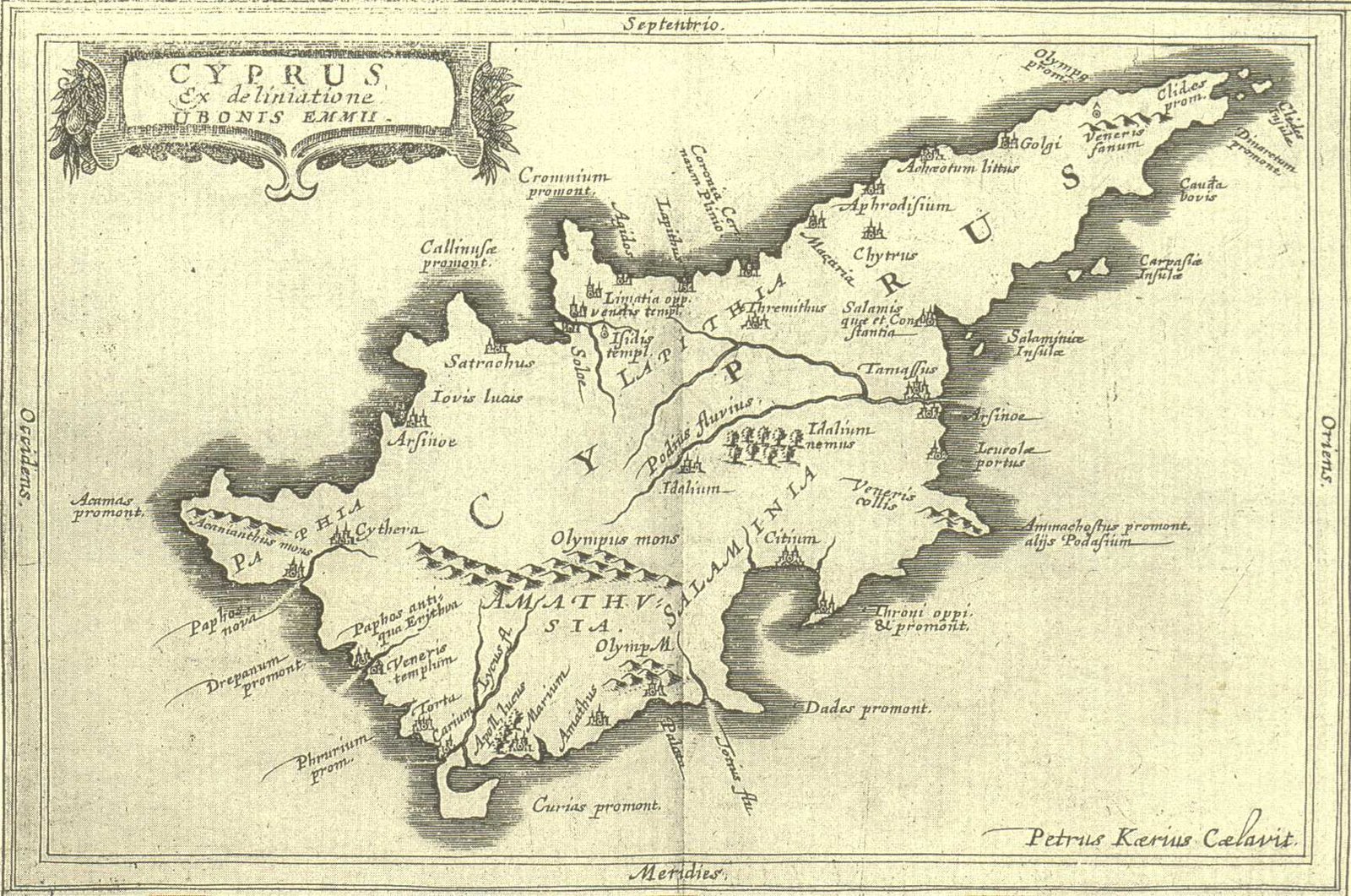 Map of Cyprus (333'504 bytes) | 1661 |
Philip CLUVER , Introductionis in Universam Geographiam...,Amsterdam 1661 & Johann Christoph BECMANN , Historia Orbis Terrarum , Geographica , Frankfurt & Leipzig 1707 . 4to (203x165mm) . Latin .
Two distinct books bound together ; both deal with the history and geography of the world and were basic geography texts with wide circulation . Culver's Introductionis in Universam Geographiam includes a map of Cyprus . The book is a small Atlas of the world with 46 maps , one of each main country . It was first published in 1624 without maps and because it was well received it went through many issues in the 17th. And 18th. centuries . However , not all Cluverius' editions contain a map of Cyprus , and those that do , show four different versions . The present edition contains the third version of the map ( Fig. 44 of 1661 above) and it is of particular importance because it was published by Joannes Janssonius . The map of Cyprus is by the famous Dutch engraver Petrus Kaerius . Cyprus is the 42nd map in the "Index Tabularum". It is a double-page map , preceding page 127 at the end of Liber V where the text on Cyprus begins (pp 127-128). The title reads "Cyprus Ex deliniatione Ubonis Emmii" (130x195mm) . Emmius was a cartographer , who worked for Hondius and Janssonius . The map is based on the Parergon (1584) map of Ortelius (Fig. 11) but its shape is rather deformed and it has fewer ancient contents . |
Mallet, Alain Manesson
 Map of Cyprus (202'062 bytes) | 1683 |
Alain Manesson MALLET , "Isles de Cypre" (140x98mm) page 297, Description de l' Univers , Paris 1683 . French . Coloured .
This map , not recorded in the Stylianou book , The History of the Cartography of Cyprus , is included in the Description de l' Univers first published in French by D. Thierry in Paris in 1683 . The author , Mallet , was an engineer , and the book which was in five volumes contained maps , plans and city views . In the first edition , the map of Cyprus has a page number (297 in the top right corner) and text on verso . This map comes from the original plate . (see also Fig. 62 of the 1719 German edition for differences of the two plates) . |
Peeters, Jacques
 Map of Cyprus (778'574 bytes) | 1685 |
Jacques PEETERS , " Cipre "-" Cyprus Insula " (137x206mm) , Description de principales villes , Antwerp after 1685 .
Peeters was an engraver and a publisher . His Description des principales villes... contained 143 copper engravings of Greek cities , harbours and islands . The amazing characteristic of his map of Cyprus is that it ignored all the valid prototypes of Cypriote cartography and chose to copy the deformed map of Cyprus which Beauvau published at the beginning of the 17th. century (Fig. 32) . His signature , "J. Peeters excudit", appears at the end of a list of place names that correspond to arabic numbers on the map , a feature also taken from Beauvau's map . Peeters added a cartouche , sailing ships , Aphrodite drawn by swans and other decorative features around the map . |
 CY +357-96-38-39-40
 RU +7 965 2 38-39-40
 UA +38-073-738-39-40
 WhatsApp
 Messenger
 Сообщение
 info@24glo.com
Главная
| ▲
| Контакты
Copyright © 24GLO LTD ® 2004-2025. All rights reserved.
 Адвокат-юрист
 Компания
 Доверенность
 Сертификат
 Апостиль
 Нотариус
 Шенген